
GIS
Precise Analytics At Your Fingertips
Our GIS services transform raw information into actionable insights that fuel your decision-making. From mapping and analysis to real-time tracking and predictive modelling, we have the tools and expertise to help you visualise, understand, and leverage the spatial dimension of your data. As Chartered Geographers (GIS), you can be assured that your data is in good hands.
Situational Awareness
Generating products that allow stakeholders to understand the current state of any project. This allows customers to accurately portray where assets are located, where critical infrastructure is damaged, or understand where archaeological phenomena are positioned in relation to other features.
Our team has provided these services to industries such as, security, construction, mining, and aviation all with one common theme - providing the most visually striking products so that even the finest of details are identified.
Location Intelligence
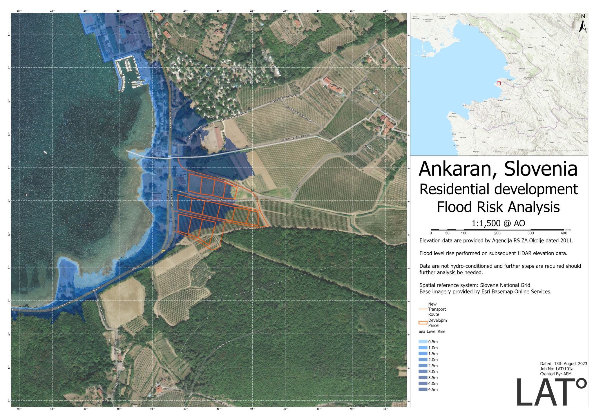
With our innovative services, we can assist you with analysing and decoding your geospatial data. This could be to find a suitable building site, understand where crime hotspots are, analyse socio-economic data, flood inundation, or identify the best route to aid with your logistics operations.
Our team of professionals can bring your data to life by leveraging off the shelf GIS and geoprocessing tools. Through the use of AI and Machine Learning, we have assisted with projects for improved Land Use assessments, analysed and visualised health access for the poorest and most deprived areas, dead ground studies for telecoms, and aided construction companies in understanding the impact of flooding on their sites.
With access to our partners data repositories, we can provide some of the highest-resolution imagery available on the market. This enables customers to gather large amounts of data without the need of deploying surveying teams thus reducing overall costs and almost eliminating all health and safety procedures.
Our team can, for example, assist with assessing vegetation and water quality, understanding land classification, identifying archaeological features, ground deformation studies, and more.

3D Flythroughs
In a world where computational power has allowed the consumers of geographic data to seamlessly render 3D environments on mobile applications, these services are ever increasing and, as a result, a crucial step in any project.
Well versed in the use of various software, our team can provide 3D models that enable you to understand your environment without even needing to step foot on the ground.
Web-Maps & Applications
By enabling stakeholders to quickly collect and access geospatial data, the decision-making cycle can be increased and made more efficient. This is achieved through the use of bespoke maps and applications that can be hosted in the cloud.
Our team have implemented a number of maps and applications that have assisted with reporting of accidents and near-misses on construction sites, accurate reporting templates through the use of dashboards, and also implemented maps that allow users to visualise their data in the field without the need of paper maps.
Data Conversion
We understand that there are many data types and formats. We specialise in converting these data into formats that you, the customer, can utilise and further your business activities. Some of our conversion services include:
CAD to GIS
Raster to Vector (vice versa)
Pointcloud to Raster
Excel (tables) to GIS
Cartography
As part of our ever-expanding services, we offer bespoke map and chart generation that are for the people who appreciate geospatial data.
With over 16 years experience within the GIS community, we deliver quality analysis and products to meet your demands. Get in touch for more information on how we can support your business.
Trusted partners:


Testimonials